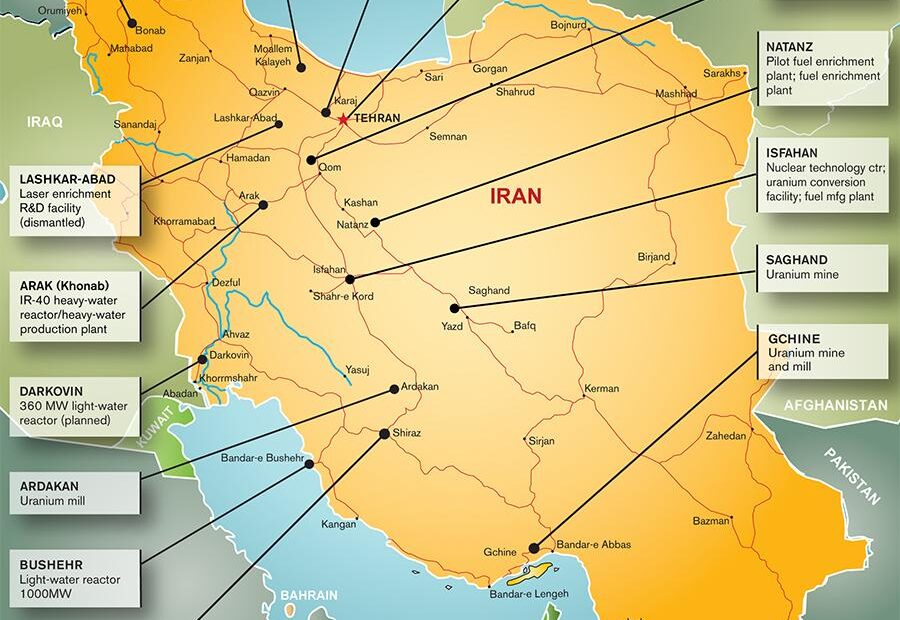
Iran’s uranium mining infrastructure is a pivotal component of its nuclear program, encompassing extraction, processing, and enrichment activities. While much attention is given to enrichment facilities like Natanz and Fordow, understanding the full scope requires delving into the country’s mining operations. This article provides an interactive map and detailed insights into Iran’s primary uranium mines.
🔍 Key Uranium Mining Sites in Iran
Iran’s uranium mining activities are concentrated in several regions, each playing a crucial role in the nation’s nuclear fuel cycle.
1. Saghand Uranium Mine
- Location: Near Yazd, central Iran
- Coordinates: 32°18′47″N 55°31′48″E
- Details: Iran’s first operational uranium mine, activated in 2005. The deposit is estimated to contain 3,000 to 5,000 tons of uranium oxide over an area of 100 to 150 square kilometers. Wikipedia
2. Gchine Uranium Mine
- Location: Near Bandar Abbas, southern Iran
- Status: Closed
- Details: Previously a significant source of uranium ore, the Gchine mine has been inactive in recent years.
3. Narigan Mining and Industrial Complex
- Location: Bafq, Yazd Province
- Status: Operational
- Details: A key facility in uranium extraction, Narigan supports Iran’s nuclear fuel cycle. Iran Watch
4. Ardakan Yellowcake Production Plant
- Location: Ardakan, Yazd Province
- Status: Operational
- Details: Processes uranium ore into yellowcake, a concentrated form of uranium oxide. Iran Watch
5. Bandar Abbas Yellowcake Production Plant
- Location: Bandar Abbas, Hormozgan Province
- Status: Closed
- Details: Formerly a site for yellowcake production, this plant has ceased operations. Iran Watch
🗺️ Interactive Map: Iran’s Uranium Mining Infrastructure
To visualize the distribution of these sites, refer to the interactive map provided by ExploreNuclear. This map highlights key facilities involved in uranium mining, processing, and enrichment across Iran.
🧭 Understanding the Uranium Supply Chain
Iran’s uranium supply chain begins with extraction at mines like Saghand and Narigan. The ore is then transported to processing plants such as Ardakan, where it’s converted into yellowcake. This intermediate product is further processed into uranium hexafluoride (UF₆) gas, which is essential for enrichment activities at facilities like Natanz and Fordow.
⚠️ Recent Developments and Strategic Implications
In June 2025, Israel conducted airstrikes targeting several of Iran’s nuclear facilities, including enrichment sites at Natanz and Fordow. These attacks disrupted operations and raised concerns about the security of Iran’s nuclear infrastructure. The Isfahan facility, intended to become Iran’s fourth operational enrichment center, was also identified as a target. However, its inspection has been delayed due to the ongoing conflict. Reuters
🧩 Conclusion
Iran’s uranium mining operations are integral to its nuclear program, supplying the necessary raw materials for enrichment and reactor fuel. Understanding the locations and functions of these sites provides valuable insight into the nation’s nuclear capabilities and the geopolitical dynamics surrounding them.
I just could not depart your site prior to suggesting that I actually enjoyed the usual information a person provide to your guests? Is gonna be again regularly to investigate cross-check new posts.
hello!,I really like your writing so a lot! percentage we keep in touch more about your article on AOL? I need a specialist on this space to unravel my problem. Maybe that is you! Having a look ahead to peer you.
Whats Taking place i’m new to this, I stumbled upon this I have discovered It absolutely helpful and it has aided me out loads. I hope to contribute & aid other users like its aided me. Good job.
Good write-up, I¦m regular visitor of one¦s blog, maintain up the nice operate, and It’s going to be a regular visitor for a lengthy time.
Yeah bookmaking this wasn’t a speculative decision outstanding post! .
I?¦m no longer positive the place you’re getting your information, however good topic. I needs to spend some time studying much more or figuring out more. Thanks for great information I used to be on the lookout for this info for my mission.
You are a very smart individual!
Hi! I could have sworn I’ve been to this site before but after checking through some of the post I realized it’s new to me. Anyways, I’m definitely happy I found it and I’ll be book-marking and checking back often!
Rattling excellent info can be found on web blog.
Thanks for sharing. I read many of your blog posts, cool, your blog is very good.
Hi there, just became aware of your blog through Google, and found that it’s really informative. I’m going to watch out for brussels. I’ll be grateful if you continue this in future. Many people will be benefited from your writing. Cheers!
Can you be more specific about the content of your article? After reading it, I still have some doubts. Hope you can help me.
Your article helped me a lot, is there any more related content? Thanks!
Excellent read, I just passed this onto a colleague who was doing a little research on that. And he actually bought me lunch because I found it for him smile Therefore let me rephrase that: Thank you for lunch!
Thank you for your sharing. I am worried that I lack creative ideas. It is your article that makes me full of hope. Thank you. But, I have a question, can you help me?
I don’t think the title of your article matches the content lol. Just kidding, mainly because I had some doubts after reading the article.
I don’t think the title of your article matches the content lol. Just kidding, mainly because I had some doubts after reading the article.
Your article helped me a lot, is there any more related content? Thanks!